

DJI Ground Station Pro drone app for serious and professional drone users who want to create complex autonomous flight paths. It’s designed to make the process of creating these paths easier by automating it.
The user selects an area on the map that he or she wants to survey, and the app automatically creates a flight path that covers the entire area, giving you the ability to adjust the amount of detail that is needed.
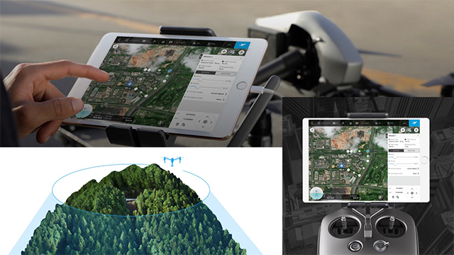
GS Pro (also known as Ground Station Pro) is an iPad app designed to controlor plan automatic flights for DJI aircraft. Through its clear, concise interface,complex flight missions can be planned with a few taps. GS Pro will thenautomatically take pictures at pre-set waypoints, providing the accuracyrequired for precision mapping.
A Virtual Fence feature increases safety andease of use by locking the aircraft’s height and speed within a designatedarea.
[amazon bestseller=”dji mavic mini” items=”3″ grid=”3″]
With these features, GS Pro dramatically increases the efficiency ofvarious industrial applications, including but not limited to, aerial imaging, architecture, precision agriculture, electrical inspections, search and rescue,safety control, and more.
DJI Ground Station Features
DJI Ground Station works with most modern aircraft, Phantom 3 and 4, Inspire 1 and 2, Mavic, M600 and other A3 and N3 drones. Next we will highlight its main features:
Virtual Fence
Select the area where the drone is allowed to fly. GS Pro will alert you if the drone comes close to the borders and will stop it from leaving this area.
Flying in this mode also puts the drone in “Joystick” flight mode, which aggressively minimizes the drift that happens when you let go of the sticks and the aircraft still has some momentum. This makes the flight more precise since the aircraft only moves when the user requests it via stick movement when you let go of the sticks, the drone stops as quickly as possible.
Waypoint Flight
Waypoint flight lets the user specify several coordinates, and create a path for the drone to follow. It’s possible to specify settings for each waypoint (altitude, gimbal pitch, drone orientation, etc.) and also to specify actions to perform at each waypoint (start recording, stop recording take a picture, hover, etc.)
When the flight is finished, you can decide what the drone does: hover, return to home or land. Since the takeoff and landing points can be different, you could use this waypoint mode to transport objects with your aircraft.
Also, since it’s possible to record video and to orient both gimbal and drone, it can be useful for these difficult shots that you just can’t take manually.
[amazon bestseller=”dji mavic air” items=”3″ grid=”3″]
3D Scan Area
Another important use of waypoint flying is photogrammetry. When flying surveying missions, knowing which area is covered and maintaining a proper overlap is important. That’s why GPS based flights are so useful for this task.
Ground Station Pro offers a 3D Scan mode, that lets you specify an area to map as well as several parameters such as height, speed, and overlap.
Unlike other apps, the area doesn’t need to be a rectangle. You can specify a complex polygon and GS Pro will create the flight path for you and take the pictures at the appropriate distances. If you are an advanced user, you can also customize front and side overlap, gimbal pitch and other parameters.
[amazon bestseller=”dji drone” items=”3″ grid=”3″]


Visitor Rating: 5 Stars